Libyan rebels still hold much of the country’s western coastal strip, including their de facto capital in Benghazi.
Time for a little geography lesson. Benghazi is in the east.
 Credit: blogger Robert Price of Colorado
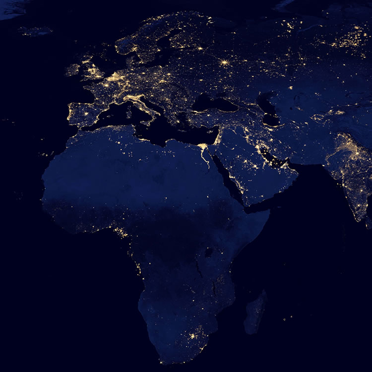
The population density map is apparently based on administrative divisions and understates the polarisation. Similar map here. As Google Earth and night views from satellites show, to a first approximation Libya consists of a thin populated ribbon along its 1,770 km coastline, with an enormous Altogether Uninhabited Interior bar scattered oilfields, oases, camels, Bedouin, and legacy minefields from the Afrika Korps and the Eighth Army.
The ribbon is not of even density and most of the population is either in the western strip (Tripolitania) or the eastern (Cyrenaica). The rebels hold Cyrenaica, and its main cities Benghazi and Tobruk. Gaddafi holds Tripolitania, with a rebel enclave at Misurata.
According to this Tripoli-based site, presumably functioning with Gaddafi’s approval,
About 80 percent of Libya’s proven oil reserves are located in the Sirte basin, which is responsible for 90 percent of the country’s oil output.
The gas is in the west, but of lower value and tied up in long-term supply contracts. The gas pipeline to Italy has anyway been closed, apparently at the initiative of the Spanish and Italian companies running the fields. Gaddafi can’t be getting much money from either oil or gas.
The oil map was, one assumes, relevant to the decision by the international coalition’s decision to back the rebels. But there’s a snag. Most of the pipelines run to the coast at small towns in the Gulf of Sidra between the main areas of government and rebel control, Ra’s Lanuf and Mersa Brega – which Gaddafi’s forces have retaken. The rebels have got to take them back, or else build new pipelines to the terminal at Tobruk they already control. From what I’ve seen on TV, they don’t have the sort of forces capable of taking a town defended by regular troops with armour; and the coalition has ruled out giving them any. New pipelines will take time.
We haven’t heard much from the oilfields. I trust the coalition is stretching the truth about “no ground troops”, and that the drillers have had their security reinforced willy-nilly by very fit young men of various nationalities and unclear identities who don’t know much about drilling mud but seem pretty handy with radios, explosives and small arms. The Brits among them will remember that the area gave birth to the forerunner of the SAS.
Stalemate and de facto partition look the likeliest short-term outcomes. If Gaddafi collapses, it will be due to the invisible economic warfare imposed by Security Council Resolutions 1970 and 1973, rather than because of the flashy no-fly zone.


I’m having a hard time figuring out the units of population density…
1. persons/square mile
2. persons/square km
3. something else?
The national bank allegedly hold 143 tons of gold – more than $6 billion – not counting whatever hard currency it holds. He doesn’t need to earn money for many months at least.
Thanks for this, James. I’ve been thinking that de facto partition seemed pretty likely as well (and I hereby pre-empt the rights to jokes regarding “a line in the sand”).
well, the only west facing coast in Libya is in the east.
Warren: Where is the gold? If it’s not physically in Tripoli, and consists of labels on gold bars in Zürich, it’s no use to him. And just how is he supposed to transport gold in tonnage quantities to Dubai (or maybe not, the UAE have sent jets to help overthrow him) or some other market where he can sell it? Back-street dealers in Bulawayo or Caracas or Minsk can’t absorb the quantities he needs.
HyperIon: Prince’s map shows absolute population, density is inferred. The other linked map from bestcountryreports shows population per square km. Either way, my point is that any choropleth map using administrative divisions is misleading in the circumstances. viz. 78% coastal urbanization. What we really need is a population dot map, as here for China. A satellite night map is a reasonable cheap-and-cheerful proxy for this. You have to discount the bright patches in the desert which must be oil- or gas-field flares.